File:Spice Islands (Zanzibar highlighted).svg
.svg)
.svg&action=edit&redlink=1)

Size of this PNG preview of this SVG file: 486 × 599 pixels. Other resolutions: 195 × 240 pixels | 389 × 480 pixels | 623 × 768 pixels | 831 × 1,024 pixels | 1,661 × 2,048 pixels | 713 × 879 pixels.
Original file (SVG file, nominally 713 × 879 pixels, file size: 11 KB)
.svg)
Any autoconfirmed user can overwrite this file from the same source. Please ensure that overwrites comply with the guideline.
Summary
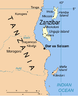
| Description | Part of the map of Tanzania, showing the Spice Islands, and highlighting Zanzibar. |
| Date | |
| Source | Vectors self-made in Inkscape. Source was cropped from 2003 Political map of Tanzania at Perry-Castañeda Library Map Collection — Tanzania. The maps are attributed to the US Central Intelligence Agency. |
| Author | Mysid |
| Other versions |
Derivative works of this file: Image:Spice Islands (Tanzania).svgin French : Image:Spice_Islands_Tanzania-fr.svg in French : Image:Spice_Islands-Zanzibar_highlighted-fr.svg in Arabic: Image:Spice Islands (Zanzibar highlighted)-ar.svg |
| SVG development |
_el.svg)
_sv.svg)
.svg)
-ar.svg)
Licensing
| I, the copyright holder of this work, release this work into the public domain. This applies worldwide. In some countries this may not be legally possible; if so: I grant anyone the right to use this work for any purpose, without any conditions, unless such conditions are required by law. |
File history
Click on a date/time to view the file as it appeared at that time.
| Date/Time | Thumbnail | Dimensions | User | Comment | |
|---|---|---|---|---|---|
| current | 17:57, 2 November 2024 | | 713 × 879 (11 KB) | wikimediacommons>Dchestnykh | Redo the previous version in vector |
File usage
No pages on the English Wikipedia link to this file. (Pages on other projects are not counted.)
Global file usage
The following other wikis use this file:
- Usage on simple.wikipedia.beta.wmcloud.org
.svg)